Map layers & styles
The layer control sits collapsed in the top-right corner and covers two different things at once.
The top part is the base map style: radio buttons let you switch between OpenStreetMap (the default), Satellite, OpenCycleMap, and Topographic, whichever ones are enabled on the server. On a phone or tablet with a high-resolution screen, OnRouteMap swaps in a sharper OpenStreetMap tile set automatically, so you get a crisp map without picking anything yourself; larger high-resolution desktop displays keep the standard tiles.
Below that are the visibility toggles, grouped under a few bold parent checkboxes: Route on its own, POI with every category nested underneath it, and Bookmarks with favorites and imported GPX waypoints underneath. Toggling a parent switches everything under it at once, and shows a dash instead of a checkmark whenever only some of its children are on, so you can hide a whole group in one click or fine-tune individual categories underneath it. Toilets start out unchecked, since they tend to be the most numerous marker on a map and easily crowd out everything else; tick the box if you want them back.
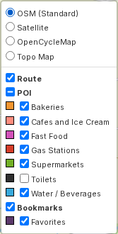
Whatever you choose here is remembered per map in your browser, so reopening the same map later keeps whatever you had hidden, hidden.
Tip
Holding down the M key temporarily hides the route line, which is handy for peeking at what's underneath a dense cluster of markers. Let go and the route comes right back.